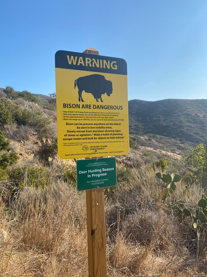
 The #GettingHigh tour continued this weekend on Santa Catalina, one of California's Channel Islands. Catalina Island is only about 76 square miles and is home to spectacular trails, including the Trans Catalina Trail (TCT), and 52 miles of coastline. It is a short boat ride from Los Angeles and an amazing getaway for those who seek nature with a few modern conveniences. WHERE TO STAY IN CATALINA Catalina Island has two main boat docks that are serviced by the Catalina Express. On the east side of the island is the well-developed city of Avalon with restaurants, hotels, shops, a botanical garden, and even concerts and festivals (during non-COVID times). It's a great location for families and people who seek more leisurely recreation. There are only a handful of cars in Avalon (most people travel by golf cart) so walking around is easy and safe. However, like the rest of the island, the town is built on an incline so expect to walk uphill a lot (or catch a shuttle). The west portion of the island is the more remote Two Harbors (where I stayed during this trip). I use the word "remote" loosely as most real campers will call this "glamping". Two Harbors campsite is set up on a tiered section of the island that overlooks the ocean so there are no bad sites. Each site has a picnic table, fire pit, and a shade structure. There are porta-potties that are cleaned often, outdoor showers (cold water, light stream), and water spigots near each site. Keep in mind that there are no bears on Catalina Island but there are island foxes and sea gulls that will break into your unattended food so store it well. There are also yellow jackets so if you're allergic, pack your meds. The small town boasts a general store that has a produce section, grocery staples, souvenirs, and brewed coffee after 8am. There are a couple of cafes with beach cabanas and (perhaps the best money spent) there's a gear haul service from the dock to the campsites so you don't need to carry all your crap the hilly half mile to and from your site. Two Harbors attracts a wide range of campers including those who are backpacking the 38.5 mile Trans-Catalina Trail, families looking for a weekend in nature, single people finding solace, groups of friends looking for adventure, and boaters who dock in the harbor. Some of these groups are quiet and some are not so quiet. Expect some partiers but know that there are quiet hours from 10pm to 9am that are enforced. Ear plugs are a good idea! For those who prefer not to sleep on the ground, there's the Banning House Lodge - a 12 room bed and breakfast in the heart of town - and a few short term rentals. PLANNING I have been to Catalina Island several times in my life, including in 2015 when I completed the Catalina Marathon - a 26.2 mile trail race that started in Two Harbors and ended in Avalon. Because I was there for a race, I just went in the direction they pointed and didn't learn much about where I was going. For this trip, I was eager to learn more about the area and trails. I started by going to the Catalina Island Conservancy website and discovered they have a free Naturalist Training program. After registering, I watched two short videos about the island's history, formation, ecosystem, and animal inhabitants and then participated in a live webinar. It was a terrific, informative program that gave me an appreciation for the environment I'd be going into and I highly recommend it for anyone curious about the ecology. They are now offering a Junior Naturalist program too! I bought a trail map from Amazon (I prefer paper maps over apps to give me a sense of the trail system) and looked at the Alltrails.com app for ideas and reviews. I also checked out SoCal Hiker and Modern Hiker for info that have a good overview of Catalina Island trails but focus on the larger trail systems like the Trans-Catalina Trail and campsites. It was difficult to find much info about shorter hikes so I decided to just figure it out when I got there. Here's what I learned:
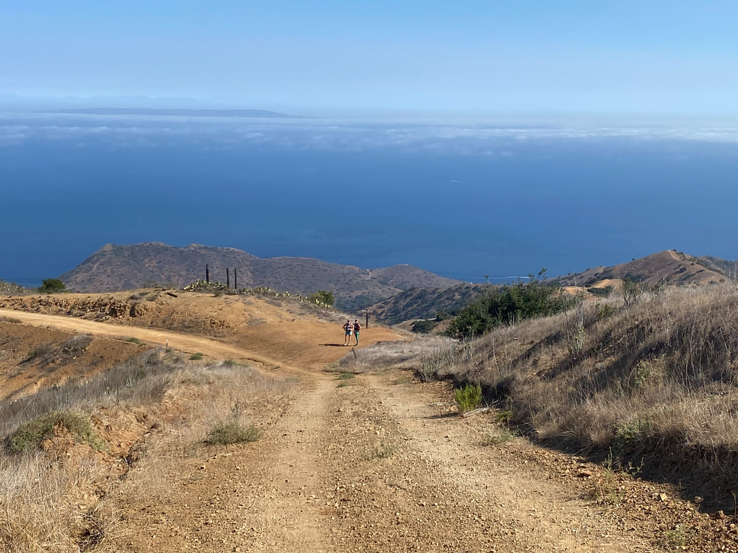
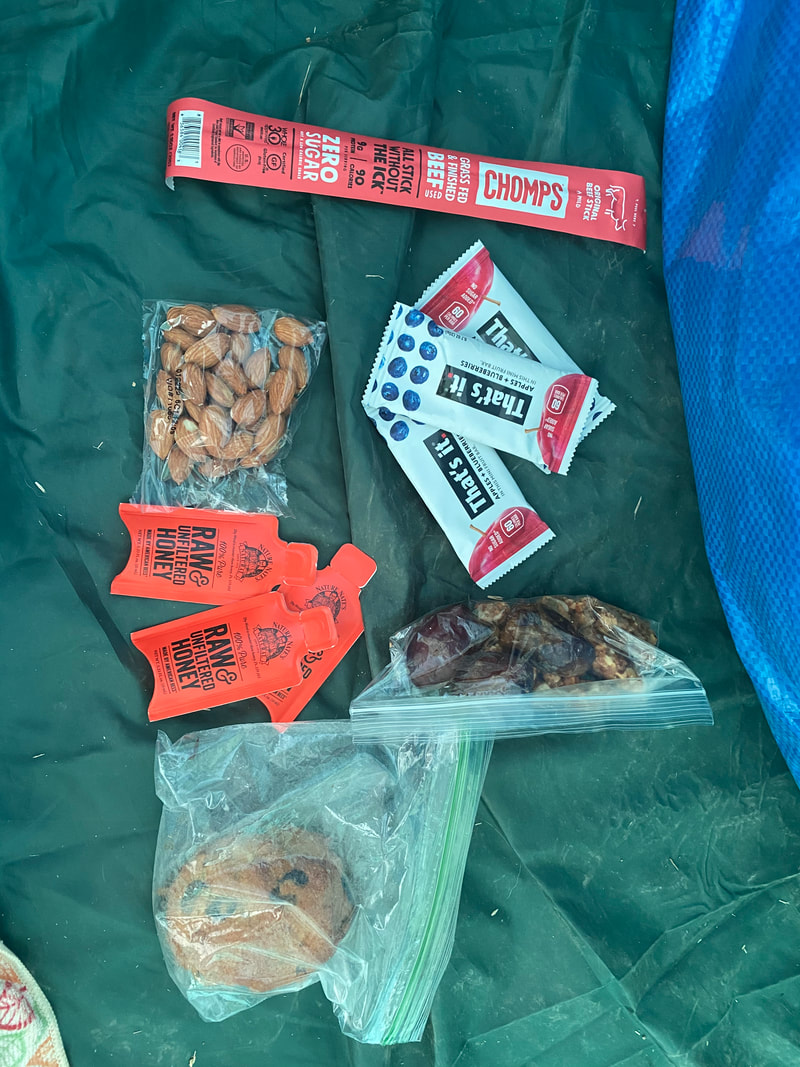
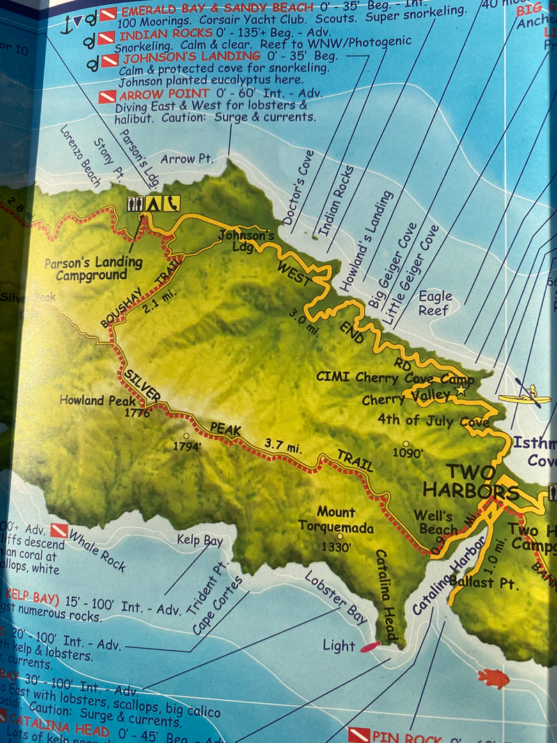
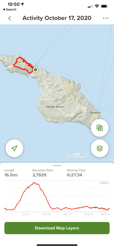
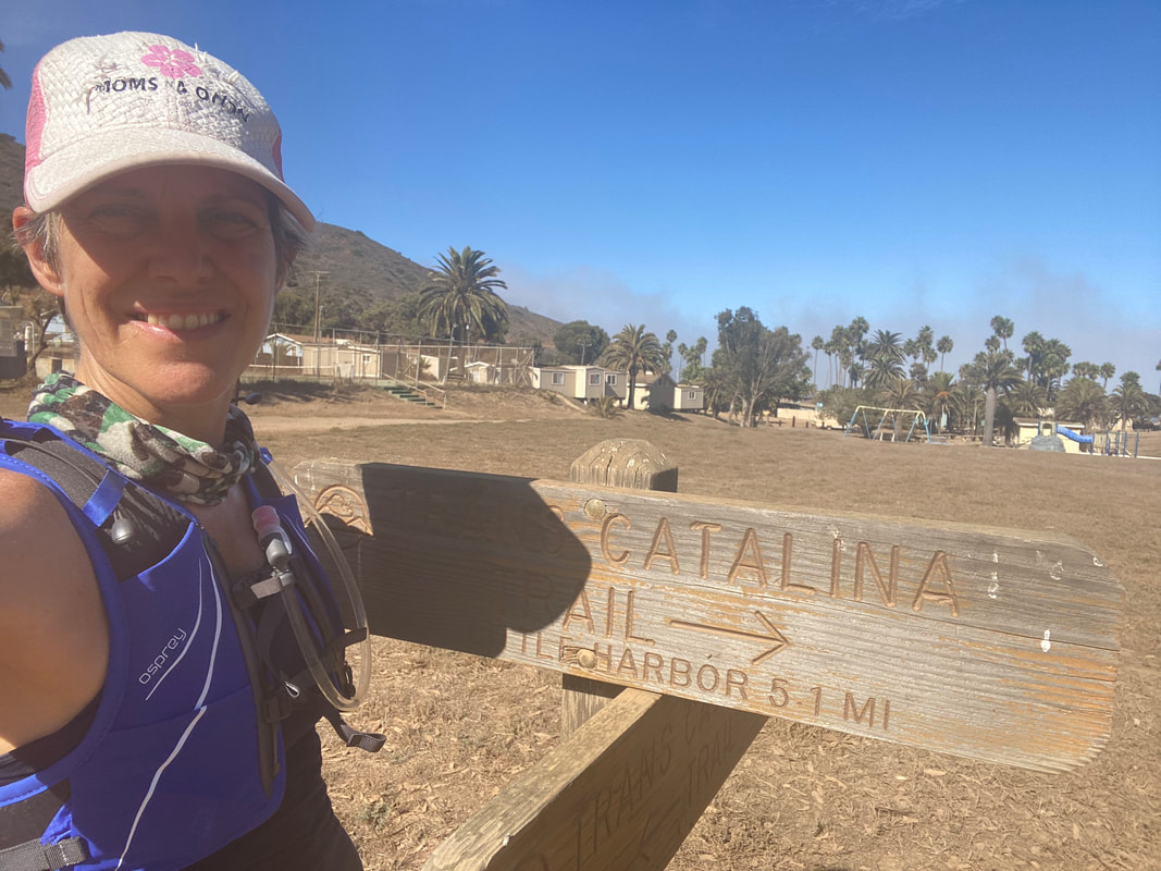
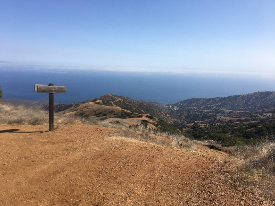
CRAZY HIKE - Two Harbors, Trans Catalina Trail, Boushey Canyon Road, West End Road (16 miles) I was only planning to be on the island for two nights so with travel time, that meant only one day for a significant hike. I intend to come back to complete the full 38.5 mile TCT in December or January but for now I opted to explore the west side of the island and found a challenging 16 mile loop that had both massive climbs and flats. There was a 1,700 ft climb in the first 3 miles then a sharp downhill that descended the 1,750 ft in just 2.5 miles! Hence it was nicknamed, Crazy Hike. The trail started just behind the town of Two Harbors. After walking back towards the Isthmus Yacht Club, there's a wooden sign directing travelers to the TCT (you can go left that will take you on the trail towards Avalon or stay straight for the hike I would be doing). Taking the trail along the right side of the harbor is flat and scenic. This one mile walk is at sea level and very pretty with pelicans diving into the harbor - it's a nice family hike or easy post-dinner walk. The section of the TCT that we would be starting on was at the very end of this dirt road (I was fooled and terrified when I saw a scrambley single track path that looked like a trail about half way down the road but that - to my relief - was not the course). The main trail has a marker at the trail head that says Trans Catalina Trail and is a well maintained dirt road. The ascent starts here. This first section was 3 miles and 1,750 feet and took about 2 hours to climb - though admittedly we did stop frequently to take in the views of ocean, hills, and flora that became more spectacular with each step. The west section of the island is quiet short (only about 10 miles long), so being on top of the world didn't last long and less than a mile later we were heading downhill again along the Boushey Canyon Road. (Side note - I should mention here that we hadn't actually intended to take Boushey Cyn Road but got confused. The road we meant to take - Fenceline Road - was a little further up the trail and would have taken us down to Parson's Landing campsite where there is water, porta potties, and picnic tables). The descent was steeper than the ascent and there were some loose rock so the downhill took almost as long as the uphill! I was grateful for my Black Diamond hiking poles to steady my journey just a bit. Because we took Boushey instead of Fenceline, we ended up in the middle of Camp Emerald Bay - a Boy Scout Camp that was not in use. Even though signs were not inviting, we were able to walk in and take advantage of sinks for filling up our water and a bench to eat lunch. I'm so grateful for this location because this was the last water stop we saw for the rest of the hike. From the Boy Scout Camp, we walked to the water and headed onto the west trail that stayed pretty flat and continuously beautiful as it winds along the mountain scape just above the ocean. This section was about 9 miles long and very runnable. While it passed some deserted private camp sites, the trek down to them was steep and challenging and would've been particularly difficult on tired legs. There was, however, a bathroom along the trail about 3 miles away from Two Harbors which is good to note if taking a walk along this flat course from town. There were several off-shoots from the TCT that would have made this hike shorter. The Watertank Road veers off the TCT about 1,300 ft into the initial climb. Another steep but well maintained trail, it connects with West End Road and makes this an 8 mile loop. There is also Goat Whiskers Trail that looked like single track and much more advanced (it connects with the West End Road right at the bathroom I mentioned above). THE UPSHOT This hike ended up taking just over 6 hours and was well worth the sweat and noodle-legs. The climbs were really tough, but the views more than made up for it! Preparation is key. I had a hydration pack that can hold 2 liters of water that I refilled at mile 7. I also carried snacks that added up to about 600 calories including dates; SCD Breakfast Cookies that were packed with nuts, raisins and apple chunks; Nature Nate's honey packets, raw almond packets from Trader Joes; Chomp's beef jerky sticks (please note that these are not confirmed SCD so if you are new to the diet it's recommended you make your own); and That's It bars (I wish I'd brought some fresh fruit like a tangerine or apple that typically hold up well in a pack). I took sun protection seriously with all the precautions I listed in my Skin Protection on the Trails post. The cell reception is poor on the far side of the island so I'm glad I took screen shots of my trail map to reference along the way.
1 Comment
Rosa Melendez
10/19/2020 04:18:15 pm
I’m ready to go. Loved following along on your trip through your blog. Leave a Reply. |
About the Gutsy Runner!Lucie is a runner, hiker, and fitness coach who follows the Specific Carbohydrate Diet (SCD) for her ulcerative colitis. She is currently on a year long birthday celebration that includes covering 2021 miles on foot and exploring some of the areas most iconic and beautiful trails. Read more Archives
November 2020
Categories
All
|


 RSS Feed